
×
Hereweg
Wood Park
2/9
Development of the Hondsrug
Wood Park
True "terra alta" of the north of the country, the Hondsrug is a remarkable geological phenomenon from the Ice Age bearing witness to geo-historical heritage, human history and different landscapes: a territorial ecosystem to be amplified for climate improvement.
On one side historical maps illustrating a high density of trees near homes and along the roads, on the other one the observation of urban, peri-urban and territorial forests around Groningen, brought us to envision the “Hondsrug wood”.
Replanting Hondsrug in the interests of climate resilience is an open intention to imagine a new urban landscape regenerated by trees.
Groningen bears the name of “Green”: this is exactly the image we wish to amplify on the Hereweg road. The “Woud Park” project begins with the strengthen of this linear landmark infrastructure. Like a large forest alignment, the plantation "Green ridge” proposes a vegetal densification to form a linear corridor with a fertile brown layer below. In our vision of a territorial climate trajectory for 2100, the park can gradually become a forested agrosystem.
“Forest Stripes” define the sloping territory of the Hondsrug. Here, new paths are envisioned and multifunctional clearings open up to new ecological and economic practices. The project of covering the southern ring-road of Groningen is an ideal incentive to combine agriculture and forestry: a "bocage-permaculture" program could unite residents around the agroforestry of the future.
In the urban areas, the “Woud Park” is intensified with the creation of “Biodiversity Nodes” evocative of natural forests, in order to create new green lungs for the Hondsrug. In particular, for the Haren square we propose a “Crown canopy”, which offers a reinterpreted species richness reminiscent of the original Hondsrug forest.
A forested past
Development of the Hondsrug
Hereweg/Rijksstraatweg as a green connection
Transformation of key places
From street to green ridge
From highway infrastructure to cultivated strips into the woods
From mineral square to park place: the crown canopy
View of Town Hall Square
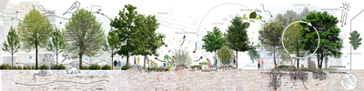
View of Hereweg
Woudpark Hondsrug
View from Haren to Groningen
Terra Alta of the North
Scale model of Agence TER
About the designers
Agence TER
Agence TER was founded in 1986 by Henri Bava, Michel Hössler and Olivier Philippe. As landscape architects coming from different horizons they have developed and shared a collective and international approach during three decades. The name of the Agency unites these «three» (ter in Latin) with the working of the soil (terre in French) and the base of all humanity, the «Earth» (La Terre in French) signifying engagement for the planet.
The Agency, created in Paris, rapidly developed outside France to follow international missions. Michel Hössler directed a branch in French Guiana during fifteen years, leading the elaboration of urban planning documents for the island of Cayenne; approaching urbanism through the landscape. Henri Bava created the Ter Karlsruhe Agency in Germany, which he managed personally for 6 years to develop projects including major transnational territories and the redevelopment of industrial wastelands. Olivier Philippe in France led large urban projects including the realisation of public spaces and many of the major contemporary parks of Agence Ter. Today, from Paris, they develop projects in France and abroad with three new agencies based in Barcelona, Shanghai and Los Angeles.
The Agency, created in Paris, rapidly developed outside France to follow international missions. Michel Hössler directed a branch in French Guiana during fifteen years, leading the elaboration of urban planning documents for the island of Cayenne; approaching urbanism through the landscape. Henri Bava created the Ter Karlsruhe Agency in Germany, which he managed personally for 6 years to develop projects including major transnational territories and the redevelopment of industrial wastelands. Olivier Philippe in France led large urban projects including the realisation of public spaces and many of the major contemporary parks of Agence Ter. Today, from Paris, they develop projects in France and abroad with three new agencies based in Barcelona, Shanghai and Los Angeles.

Partners:
© 2021 Sponsland | Klimaatadaptatie Groningen